6. Iterative tie line levelling#
[1]:
%load_ext autoreload
%autoreload 2
import logging
import geopandas as gpd
import pandas as pd
import plotly.io as pio
import airbornegeo
logging.getLogger("airbornegeo").setLevel("INFO")
logging.basicConfig()
pio.renderers.default = "notebook"
/home/airbornegeo/airbornegeo/.pixi/envs/default/lib/python3.14/site-packages/tqdm/auto.py:21: TqdmWarning: IProgress not found. Please update jupyter and ipywidgets. See https://ipywidgets.readthedocs.io/en/stable/user_install.html
from .autonotebook import tqdm as notebook_tqdm
6.1. Load data#
This is a subset of the BAS AGAP survey over Antarctica’s Gamburtsev Subglacial Mountains. The file is download and subset in the notebook AGAP_magnetic_survey, and the BAS processing steps are repeated in the notebook processing_AGAP_magnetic_survey.
[2]:
data_df = pd.read_csv("data/AGAP_magnetic_survey_processed_blocked.csv")
data_df = data_df[
[
"easting",
"northing",
"height",
"line",
"unixtime",
"distance_along_line",
"mag",
]
]
# for testing limit number of lines
data_df = data_df[~data_df.line.between(133, 142)]
data_df = data_df[~data_df.line.between(168, 176)]
data_df = data_df[
(data_df.line.isin(data_df.line.unique()[::2])) | (data_df.line >= 143)
]
# define flight lines vs tie lines with column 'tie' which is True or False
data_df["tie"] = False
data_df.loc[data_df.line >= 142, "tie"] = True
data_df.head()
[2]:
| easting | northing | height | line | unixtime | distance_along_line | mag | tie | |
|---|---|---|---|---|---|---|---|---|
| 0 | 621099.093988 | 159056.748193 | 4110.45 | 1 | 1.229500e+09 | 27.181565 | -33.385 | False |
| 1 | 621206.517953 | 159071.301512 | 4114.50 | 1 | 1.229500e+09 | 135.587530 | -35.120 | False |
| 2 | 621313.794221 | 159085.113599 | 4117.90 | 1 | 1.229500e+09 | 243.749367 | -36.875 | False |
| 3 | 621420.722903 | 159099.184618 | 4120.80 | 1 | 1.229500e+09 | 351.600337 | -38.585 | False |
| 4 | 621527.158177 | 159114.303863 | 4123.15 | 1 | 1.229500e+09 | 459.104857 | -40.205 | False |
6.2. Find intersections#
[3]:
# convert dataframe into geodataframe
data_df = gpd.GeoDataFrame(
data_df,
geometry=gpd.points_from_xy(data_df.easting, data_df.northing),
crs="EPSG:3031",
)
[4]:
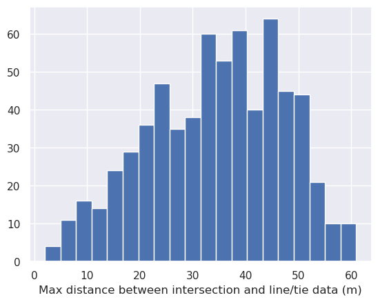
# calculate theoretical intersection points
inters = airbornegeo.create_intersection_table(data_df)
inters
Line/tie combinations: 100%|██████████| 3630/3630 [00:00<00:00, 7649.28it/s]
Potential intersections: 100%|██████████| 670/670 [00:06<00:00, 102.62it/s]
INFO:airbornegeo:found 662 intersections
[4]:
| line | tie | geometry | max_dist | easting | northing | |
|---|---|---|---|---|---|---|
| 0 | 1 | 143 | POINT (1158153 254083) | 16.441255 | 1158153.0 | 254083.0 |
| 1 | 1 | 144 | POINT (1190820 259865) | 24.124887 | 1190820.0 | 259865.0 |
| 2 | 1 | 145 | POINT (1223524 265689) | 17.269650 | 1223524.0 | 265689.0 |
| 3 | 1 | 146 | POINT (1256193 271497) | 31.608179 | 1256193.0 | 271497.0 |
| 4 | 1 | 147 | POINT (1288901 277249) | 50.174377 | 1288901.0 | 277249.0 |
| ... | ... | ... | ... | ... | ... | ... |
| 657 | 125 | 199 | POINT (1318165 302398) | 33.689493 | 1318165.0 | 302398.0 |
| 658 | 125 | 200 | POINT (1350929 308239) | 36.343660 | 1350929.0 | 308239.0 |
| 659 | 127 | 148 | POINT (1319894 292699) | 22.093103 | 1319894.0 | 292699.0 |
| 660 | 127 | 199 | POINT (1319922 292702) | 23.297236 | 1319922.0 | 292702.0 |
| 661 | 127 | 200 | POINT (1352642 298507) | 36.743873 | 1352642.0 | 298507.0 |
662 rows × 6 columns
6.3. Add intersections as rows to the dataframe#
[5]:
data_df, inters = airbornegeo.interpolate_intersections(
data_df,
inters,
to_interp=["mag", "height"],
window_width=500,
method="cubic",
extrapolate=False,
)
Line 206: 100%|██████████| 121/121 [00:10<00:00, 11.61it/s]
[ ]:
# see which lines dont have intersections
airbornegeo.lines_without_intersections(data_df, inters)
[np.int64(107),
np.int64(109),
np.int64(129),
np.int64(131),
np.int64(188),
np.int64(189),
np.int64(190),
np.int64(192),
np.int64(193),
np.int64(194),
np.int64(203)]
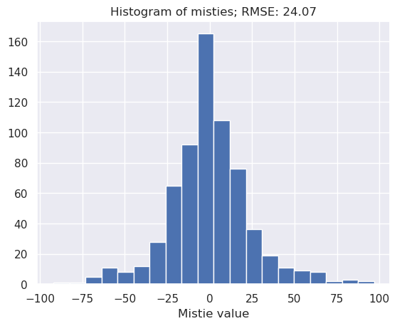
6.4. Calculate initial cross-over errors#
[7]:
inters = airbornegeo.calculate_crossover_errors(
data_df,
inters,
data_col="mag",
plot_map=True,
)
[8]:
inters.head()
[8]:
| line | tie | geometry | max_dist | easting | northing | dist_along_flight_line | dist_along_flight_tie | flight_interpolation_type | tie_interpolation_type | flight_height | tie_height | mistie_0 | |
|---|---|---|---|---|---|---|---|---|---|---|---|---|---|
| 0 | 1 | 143 | POINT (1158153 254083) | 16.441255 | 1158153.0 | 254083.0 | 545768.072695 | 138071.419338 | interpolated | interpolated | 4168.038983 | 4008.397691 | 100.458661 |
| 1 | 1 | 144 | POINT (1190820 259865) | 24.124887 | 1190820.0 | 259865.0 | 578952.394781 | 131585.125284 | interpolated | interpolated | 4174.500813 | 4010.840823 | 32.151483 |
| 2 | 1 | 145 | POINT (1223524 265689) | 17.269650 | 1223524.0 | 265689.0 | 612181.972720 | 147253.496664 | interpolated | interpolated | 3544.149925 | 3995.961216 | 72.936553 |
| 3 | 1 | 146 | POINT (1256193 271497) | 31.608179 | 1256193.0 | 271497.0 | 645372.035087 | 136211.666619 | interpolated | interpolated | 3564.579994 | 3578.174277 | 84.125118 |
| 4 | 1 | 147 | POINT (1288901 277249) | 50.174377 | 1288901.0 | 277249.0 | 678598.170740 | 155115.224990 | interpolated | interpolated | 3536.160719 | 3545.947314 | -7.731396 |
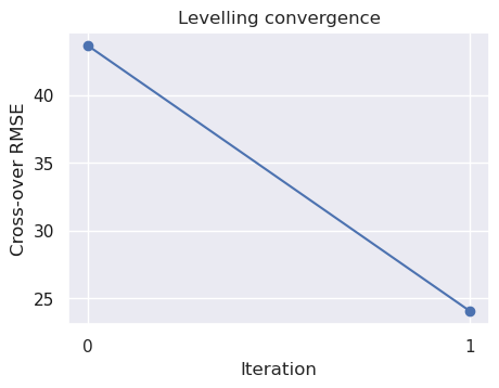
6.5. Iteratively level lines to ties#
This will perform up to 5 iterations of levelling the lines to the ties. Once the cross-over errors stop changing, the iterations will stop. Most of the time it will stop after 1 iteration, but as you’ll see in further notebooks, ones we performed weighted levelling, more iterations can be useful.
[ ]:
data_df, inters = airbornegeo.iterative_line_levelling(
data_df,
inters,
lines_to_level=data_df[data_df.tie == False].line.unique(),
data_col="mag",
levelled_col="mag_levelled",
degree=0,
iterations=5,
)
inters.head()
Iteration: 20%|██ | 1/5 [00:06<00:25, 6.30s/it]
| line | tie | geometry | max_dist | easting | northing | dist_along_flight_line | dist_along_flight_tie | flight_interpolation_type | tie_interpolation_type | flight_height | tie_height | mistie_0 | mistie_1 | |
|---|---|---|---|---|---|---|---|---|---|---|---|---|---|---|
| 0 | 1 | 143 | POINT (1158153 254083) | 16.441255 | 1158153.0 | 254083.0 | 545768.072695 | 138071.419338 | interpolated | interpolated | 4168.038983 | 4008.397691 | 100.458661 | 96.945621 |
| 1 | 1 | 144 | POINT (1190820 259865) | 24.124887 | 1190820.0 | 259865.0 | 578952.394781 | 131585.125284 | interpolated | interpolated | 4174.500813 | 4010.840823 | 32.151483 | 28.638444 |
| 2 | 1 | 145 | POINT (1223524 265689) | 17.269650 | 1223524.0 | 265689.0 | 612181.972720 | 147253.496664 | interpolated | interpolated | 3544.149925 | 3995.961216 | 72.936553 | 69.423514 |
| 3 | 1 | 146 | POINT (1256193 271497) | 31.608179 | 1256193.0 | 271497.0 | 645372.035087 | 136211.666619 | interpolated | interpolated | 3564.579994 | 3578.174277 | 84.125118 | 80.612078 |
| 4 | 1 | 147 | POINT (1288901 277249) | 50.174377 | 1288901.0 | 277249.0 | 678598.170740 | 155115.224990 | interpolated | interpolated | 3536.160719 | 3545.947314 | -7.731396 | -11.244436 |
[10]:
airbornegeo.plot_levelling_convergence(inters)
[11]:
inters = airbornegeo.calculate_crossover_errors(
data_df,
inters,
data_col="mag_levelled",
plot_map=True,
)